
_edited.png)
_edited_edited.png)
Crossing Canada Day #14: Detour into Madness and Sudbury
- Jaime Lee Lightle
- Apr 7, 2022
- 5 min read
Updated: Apr 8, 2022
We continue our Chronicles of Crossing Canada. Welcome back!
We left our camp on the banks of the Great Lake Superior as it poured down rain for our day of driving. Today’s destination: Sudbury Ontario.

Jaime Lee here...
We were looking forward to driving through Lake Superior Provincial Park today. We stopped in Schreiber for gas and coffee. The next town, Terrace Bay has an interesting history: In the mid-twentieth century, this town was developed to support the pulp and paper industry in the area. To attract and retain workers from all over Canada and the Globe, the industry invested in this town and made it a community for its employees and their families. Without this huge plant operation, Terrace Bay wouldn’t be the place it is today.
Marathon, White River, then Wawa – where our fateful detour began. According to Apple Maps, this detour from Wawa on Hwy 101 east was supposed to be 30 minutes shorter than any other route. The only problem – the navigator (yes moi), didn’t notice how far this route would take us off our intended path.
After taking the 101 East for a few km, it was not long before we noticed that there was nothing else on this road, not a camper, passenger vehicle or transport truck. That should have been our first red flag. At the junction of highway 101 and 129, we had to turn and go off course for 30-40 minutes because we needed to find gas. We were in an area with no internet signal and so no way of knowing when the next fuel up point was going to be beyond this point.

After fuelling up Chapleau (Northern Ontario rate of $1.659/L), I got in the driver’s seat. We doubled back to the original ‘detour’ route until it took us to an unmanaged dirt road and train whistle stop in Sultan Ontario. No man’s land! I slammed my fists on the steering wheel. We turned around and found a way back to paved Hwy 129 east. The first and only sign we saw was: Thessalon 198 km. Thessalon is back on Hwy 17 and 200 Km west of Sudbury. Do we take this route, or do we turn back? We decided to keep going to Thessalon.

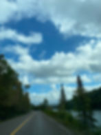
Hwy 129 had all the features of an isolated northern road: winding, bumpy and hilly. There were no signs to be seen and no vehicles passed us or followed us. We were alone with sky, trees, and the never-ending road. It felt like we were in the middle of nowhere. What if we got a flat? After about an hour and a half we saw our first transport, so we followed close behind him. I saw this a good sign that we were likely not going to run in to any other dirt roads.

We started seeing lakes and the subtle changes in colour of the carnivorous trees along this northern route. It was beautiful but my mind was on our destination – Sudbury. Again, I cursed Apple Maps as I screamed in the cab of the truck: “Why did it take us here!?” I was so mad with frustration and regret that I had to stop the truck and let Jim drive from here on out. The stress of this detour had me clenching my teeth for hours and eventually the pressure of my emotions erupted into a fierce headache. It was another 40 minutes on Hwy 129 before we surmised that the purpose of this isolated route was for access to the Algoma Headwaters and more northern routes to High Falls and the Little Long and Lower Sturgeon Hydroelectric dams.
Eventually we made it to Thessellon around the time the route said we would be in Sudbury – Apple Maps fail! Back on the Trans-Canada – finally, and James hit the accelerator. We had with the west wind at our back, and it finally felt like we were making progress. There was construction and lane closures between Massey and Espinola. Perhaps that’s why we were re-routed on the Apple GPS?
We set our sights for a comfy Hotel in Sudbury after making a quick stop in Espanola for cheap chewing tobacco. At the Holiday Inn in Sudbury ($200 night – yikes!), we were finally able to relax. We had hotel restaurant supper in our room and made plans to get the truck some much needed and deserved service the next morning. Tomorrow was also going to be a rest day for us as well.
Jim writing:
We left Rainbow Falls Provincial Park with hopes of seeing one of the most scenic drives in Ontario. We turned off in Wawa as per the directions of the Apple Maps. Bad Idea number one: Listening to technology.
While this route took us down a highway that bypassed the scenic drive, it also led us into the interior of the province. The drive took us past Hawk Junction where a First Nations colleague of mine was from. He was a great soldier.

As time went by, my frustration level was rising and there was nothing I could do about it. I felt stuck in a bad situation. When we had to detour 30km to get gas so we could make the rest of the drive on this route, my frustration raised to a boiling point.
We switched drivers in Chapleau. The truck house has been on some crazy roads but this one seemed to take the cake. Trees, lots of trees, everywhere there was trees. Sultan Ontario seemed like it was the last stop before heading deeper into an old logging road. The potholes were deep, and the road had ruts and washouts just in the short distance we drove. We turned around and headed south towards Thessalon.
At a certain point, maybe at hour two, we realized again that we had missed some of the most picturesque route of this whole trip. The anger boiled over in both of us. Jaime screamed and then started to hyperventilate and almost passed out while driving. I had to yell to tell her to put on the brakes. She put on the brakes, but she was still almost passing out. She got out of the truck and into the passenger seat. I walked over to the driver’s seat but before I did, I claimed the road as my own like an animal would. I was holding my bladder for an hour. It was needed. We were parked in the middle of Highway 129 for what felt like five minutes. There was no trucks or cars to be seen. I finished my claiming the highway, then we continued to Sudbury.

The rainstorm that we left in Rainbow Falls was upon us again. By the time we arrived in Sudbury, there were windy microbursts ready to crack open with violent wind and rain. This stormy night was spent in a hotel instead of our truck camper. The frustrations of the days travels slowly melted away. We ate our meals in the room and slowly winded down. Tomorrow, we planned on getting an oil change, stopping to see the 'Big Nickel', and finding camp in the Ottawa Valley (Champlain provincial park). I prayed we’d have better weather and better conditions all the way around. Highway 129 almost destroyed the feelings of joy we had made during this trip, but it did not defeat us.
Did you enjoy this blog post? Let us know.

Want to read more? Sign up now.

